Author :
Visualizing the future of Toronto through Google Earth
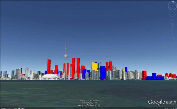
Behold the Toronto skyline of the future.
With the click of a mouse, Cale Vanderveen swoops through the Yonge St. canyon. With another, he pivots around the CN Tower, past the top of the proposed casino complex.
The 17-year-old high school student from Uxbridge is demonstrating a 3D model of the downtown core he built on his laptop using SketchUp, free 3D modeling software formerly owned by Google.
The proposed buildings are constructed in SketchUp and placed in a model of present-day Toronto from Google Earth. The result is an interactive 3D model that shows just about every future structure currently in the works, from the newly announced Gehry-Mirvish towers to those well under construction, each building colour-coded to show its stage of development.
A flyover video tour of the model Vanderveen put up on YouTube is a rare glimpse of the city to come.
It took Vanderveen about three months to construct the model in his spare time.
“I guess I just wanted to visualize the city,” he says of his hobby.
The aspiring architect became fascinated with the skyscraper boom in the city about two years ago, haunting forums on sites like Urban Toronto and Skyscraper Page. When he saw the plans for Trump Hotel, he decided to use SketchUp to see what it would look like.
Then he constructed the waterfront development … and continued until he’d mapped the entire downtown core — with a bit of Yonge and Eglinton to the north and Humbertown to the far west.

The model is not perfectly accurate, says Vanderveen. He gets most of his data from building permits and development applications available through the city’s Open Data program. Sometimes he estimates pieces from developer marketing images.
Even so, “it’s very impressive,” says Frank Lewinberg, a partner at planning and design firm Urban Strategies. “Anything that encourages public awareness and engagement with what’s happening in the city is a wonderful thing.”
But publicly sharing Vanderveen’s visualization of what the city is becoming is a challenge.
Vanderveen’s model exists only on his computer, shared publicly only through that virtual-tour video.
The same is true for the City of Toronto building model, a behemoth begun in 1987 in a program called MicroStation.
It now features 100,000 of the city’s one million structures, shown in painstaking detail, down to the slopes and dips of the terrain, says Carolyn Humphreys, program manager of the city’s graphics and visualization department.
It is the most accurate model for experiencing Toronto’s future, often used in sun-shadow testing for new buildings or sold in smaller bits to architecture firms, developers and others who need visualizations.
What’s holding the city back from sharing the model more broadly is the sheer size of the files involved, Humphreys says. But she has been considering other ways to get the public engaged in visualizing the city’s future.
She once proposed that all building applicants should make models of their projects available to Google Earth so, “you and I, at 3 in the morning, wondering what this building is really going to look like in my neighbourhood, could go in (to Google Earth) and have a look.”
The city is working on a plan to upgrade the physical model in City Hall and add a walk-through or animation of the 3D model on a screen behind it (and seeking sponsors).
Meanwhile, for Vanderveen, the near future is looking up. Interest sparked by a blog post about his model at Canadian Business last month won him a summer job at RealNet, a real estate investment research company.
“It’s just a hobby that’s exploded,” he says, laughing. “It’s kind of cool.”
- Cover Story
-
 SketchUp Can Help You Win Interior..
 -
 Best Laptops for SketchUp
 -
 How to Resize Textures and Materials..
 -
 Discovering SketchUp 2020
 -
 Line Rendering with SketchUp and VRay
 -
 Pushing The Boundary with architectural
 -
 Trimble Visiting Professionals Program
 -
 Diagonal Tile Planning in SketchUp
 -
 Highlights of some amazing 3D Printed
 -
 Review of a new SketchUp Guide
- Sketchup Resources
-
 SKP for iphone/ipad
 -
 SKP for terrain modeling
 -
 Pool Water In Vray Sketchup
 -
 Rendering Optimization In Vray Sketchup
 -
 Background Modification In sketchup
 -
 Grass Making with sketchup fur plugin
 -
 Landscape designing in Sketchup
 -
 Apply styles with sketchup
 -
 Bedroom Making with sketchup
 -
 Review of Rendering Software
 -
 Enhancing rendering for 3d modeling
 -
 The combination of sketchup
 -
 Exterior Night Scene rendering with vray


